Saturday, August 10, 2013

Denali


Denali, Alaska

July 31- August 2, 2013

Days # 18-20 of our Alaska Adventure. Well here is a very important question. Can people have too much fun, too many beautiful views, too many fun activities, too much good food??  We are attempting to answer those questions.  At this point one would have to say NO!!  This trip just continues to get better and better!  Our travel to Denali from Fairbanks was quick and uneventful. The views were a bit hazy, but one could still appreciate the mountains in the Alaska Range and the gorgeously green valleys.  After arriving at camp we set out for a helicopter flight to see Mt. McKinley or Denali as she is now called.  The weather Gods were not so cooperative, we had some pretty good thunderstorms over the mountains, so they flew us to the eastern potion of the Alaska Range (away from Denali) but we saw some amazing mountains, vistas, valleys and GLACIERS! Wow who knew that they would be so numerous and incredible.  We have seen a few glaciers on other mountains on our trip but NOTHING the size, variety and number we saw on this flight.  We did see the blue color that is visible because water is very good at absorbing light; only the strongest light with the most energy is able to escape.  The color blue has the most energy, so it can escape without being absorbed. The thicker the glacier the bluer is appears (I think I got that explanation right?).  The 50 minutes we flew vanished before we knew it.  Another fantastic experience on the “trip of a lifetime”.
Glacier view from Helicopter

Outer Range of the Alaska Range

We took a daylong bus ride into the Denali National Park. The driver was extremely knowledgeable and entertaining.  It didn’t hurt that the weather was close to perfect. We were so fortunate to be able to see Denali (Athabascan Indian word for “The High One”), the 20,322 feet tall mountain from 4 different viewpoints. We are in the 30% club; only about 30% of the visitors get to see the mountain, clouds often shroud it. The views were nothing short of spectacular: the creeks, rivers, lakes, valleys, rock formations and beautiful sky. The trip was also a good wild life-spotting event. We saw several moose, caribou and one very shy golden grizzly bear (he was hiding behind some bushes and never really did make himself very visible). The bus was outfitted with a camera that the driver could focus in on the scenes and project them onto small video screens through out the bus, this gave everyone a good view of things.
Caribou

Denali

Denali River Valley

“Ya Hoo – Ye Haw and Oh My God!!!”  We took a 2-hour whitewater raft trip on the Nenana River. What a rush it was. Because the water comes right off the Nenana Glacier less than 24 hours earlier it was COLD – about 38 degrees ----- brrrrrrrr.  We all wore dry suits that did a pretty good job of keeping us dry and warm, but the splash was still quite exhilarating. 3 other couples & Mike and I banded together for the trip. We had some discussion on the type of trip we would take: a simple float trip or a Canyon Run Excursion – the Canyon Run, it was. The girls rode on one raft and the guys on the other. Think the girls had the most fun! The views were grand, beautiful canyon to rip and roll through, splashed through 7 level III rapids—what a blast!  After returning to camp and putting on dry clothes we went up to the Grande Denali View Hotel and enjoyed a little lunch and a stunning view of the river we had just rafted and the surrounding area.
white water on the Nenana River in Danali


We enjoyed an evening’s entertainment – Nite Cabin a dinner theater – the serving staff are all singers and quite the characters.  After a good family style dinner, we enjoyed a show of skits, singing and dancing, a great ending to our Denali Experience.


Miles for the day: 124  Total miles for the AK Adventure: 1722.3

Monday, August 5, 2013

Fairbanks and the Arctic Circle


Civilization: Fairbanks, Alaska

Fairbanks is home to over 60,000 people and is the 2nd largest city in Alaska. Like most northern cities, Fairbanks has a god-rush history and enjoyed a boom in the early 1900’s. While in Fairbanks we enjoyed many unique Alaskan experiences: dinner one night at the Salmon Bake Buffet, followed by a Gold Rush review at the Palace Theater celebrating the history of Fairbanks There was the 40 Degrees Below 0 Experience, where we had our picture taken while standing in a freezer (yep, pretty cold alright).  We had a good cruise on the Discovery III, a sternwheeler modeled after the boats that carried miners, and their supplies during the gold rush; the float was accompanied by very entertaining presentations, commentaries of what we were seeing on the riverbanks and demonstrations. The seaplanes that were parked at almost every property along the riverbanks were interesting to watch take off and land.  0ne out of every eleven Alaskans have their pilot’s license.  The cruise stopped at an Athabascan Indian Village where we were told stories about the historical times of the Indians. We enjoyed listening to a talk by a young woman about her sled dogs, who will be racing in the Yukon Quest Dog Sled Race in February 2014.  Wow is that ever an arduous activity.  The afternoon was spent at a champagne brunch - more food, yet another buffet – oh my, are we ever eating well.  One of my favorite tours was visiting the Ice Museum – an old movie theater that has been converted into a showroom of ice sculptures. There were large walk-in freezers where we viewed frozen art works that had been made the previous winter at the Ice Carving Festival in the local park.  We watched as one of the sculptors carved a dolphin out of a block of ice – he used drills, dremil tools, files, hair dryers and a fan. Quite an art!
Salmon Bake

Ice Museum

cruising on the Chena, Fairbanks

New sled dog puppies

4:00am, the alarm went off, we jumped up out of bed, fed the Boys and headed off to the airport. This was our day for the Artic Circle Air Adventure. We flew in a small 7-passenger plane over some of the last great wilderness regions on earth, north of the Yukon River, across the Artic Circle: 66 degrees 33 minutes latitude (nope no dotted line that we could see from the air J) and into the Brooks Mountain Range.  We could see many miles of the Alaskan Oil Pipe Line as we flew.  Most of the 800 miles of pipeline are above ground, because of the permafrost in the region.  In approximately an hour and a half we landed in Coldfoot Alaska (home of the Farthest North Bar – not much to look at or drink, but interesting none the less).  From Coldfoot we drove to Wiseman and met a real mountain man: Jack Reikoff.  He and 13 others live in Coldfoot all year long, very different life style.  They survive by giving tours, making crafts, growing huge gardens in the summer, trapping and selling furs and preserving the resulting meat. The trip then reversed itself and we flew back from the Artic Circle to Fairbanks arriving just shortly after noon. It was a great flight and a yet another experience for the crazy North American Safari Travelers.  That afternoon we made a visit Santa’s House at North Pole, Alaska – left a note on who we think have naughty and nice.
Farthest North BAR in the World
flight to the Arctic Circle

The Arctic Circle, N66-.33

Oil Pipeline

An amazing feature of this Land of the midnight sun has been the bounty of plants, and flowers that appear to be growing everywhere in Alaska.  Stores, parks and most homes are decorated with beautiful blooming baskets, colorful flowerbeds, and incredible vegetable gardens.  It is a very short growing season of 120 days or less, but they really seem to thrive on the long 20+ hours of BRIGHT SUNLIGHT. Our Wagon Masters live in Fairbanks and we saw their amazing garden (huge cabbages, carrots, lettuce, Swiss chard, potatoes…) Wow our garden has never looked that good.

The Alaska Museum of the North on the University of Alaska Campus was an interesting visit. There were many interesting collections of contemporty and historic materials on display.  Gold Fever struck us! – We visited Gold Dredge # 8 that last operated in 1959. This 250’ long, 5-story tall machinery was impressive. Our pockets are much heavier: between the 2 of us we panned out a total of $31.00 worth of gold flecks from the little pouch of dirt we were given, wow!!  That could become an addicting hobby J.   One of the last tours we took was a visit to a check station along the Pipe Line.  This is one of the reasons that Alaska is so successful, 80% percent of the state’s economy comes from oil revenue and related services.  The taxes that the oil company pays for the line to run from Prudhoe Bay on the Bearing Sea in the north down to Valdez in the south keep the state from having to depend on sales or personal income taxes. In addition each full time resident receives an annual payment of $1000.00 or more. This sounds pretty good, but when one takes into consideration the high cost of living here, it is probably only a small incentive. 
Grizzly or Brown Bear

Anchorage Museum
Bonanza! $31.00 of GOLD


These first 6 days in Alaska have been incredible, and there is so much more to come.


Sunday, August 4, 2013

Chicken & Tok Alaska


ALASKA At Last: Chicken & Tok:

July 25-30, 2013

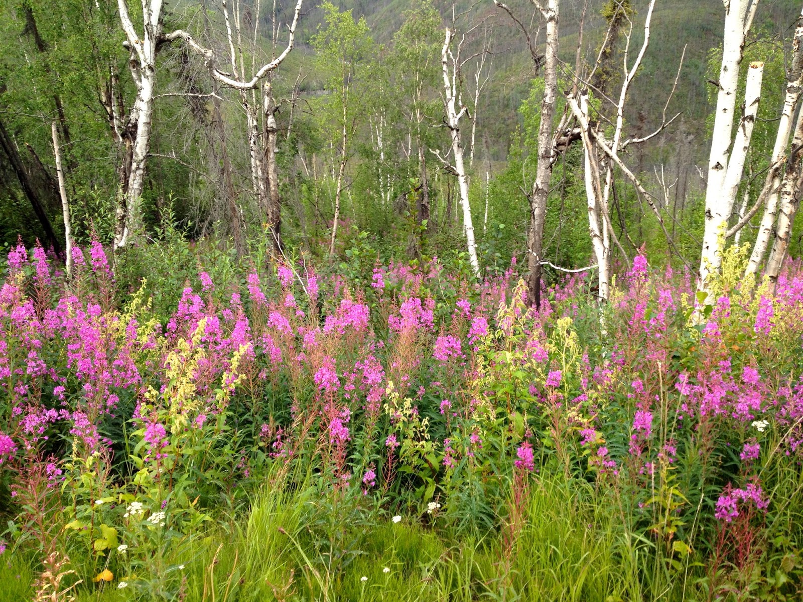
Day # 12 of our Alaskan Adventure provided us with more excitement than was expected. Our travels started out by crossing the river by ferry. The boat was small and only took 1-2 rigs on a crossing. So after about an hour of waiting I got on with the little Prious, and 3 boats later Mike made it over with the MoHo and the tow-dolly (only a 7 minute trip). We got back together, hitched up and got back on the road. Not just any road, but the Top of the World Highway. This drive climbed up from the western banks of the mighty Yukon. This could have been a very picturesque drive, but with the low clouds/fog we really could not see much on either side of us, or in front of us.  A slow 66 miles later saw us crossing from Canada back into the good ol’ USA. The road that had been fairly bumpy and narrow went from bad to worse; what the heck is Alaska doing to maintain their roads, potholes, potholes, and more potholes; washboard, washboard, and more washboards.  The weather turned from gray to wet and the dirt road became a very slippery bumpy mess. We drove very slowly (5-10 mph) for the next 40 miles or so and just tried to stay on the road, minimize the bumps and avoid the soft shoulders. Mike’s calm and skilled driving skills kept us safe and sound – after a very long day: 108 miles that took us about 6 hours we were both exhausted. Driving into the little town of Chicken the road improved, we were greeted with a beautiful view of the Fortymile River and fields of bright cheerful purple/pink fireweed.  All the rigs eventually made it into camp (one rig had to be towed out of a very slippery shoulder-took them an additional 6 hours) all of us were very grateful to be safe and sound, even though all of our rigs/tow vehicles were plastered with mud, what a sight!  The small community of Chicken (pop. 37 during the summer, 3 in the winter) was quite interesting. This little town was once a mining hub for the Fortymile District.  As the story goes the miners wanted to call their town Ptarmigan (sort of like a quail) after the bird common in the area. Unfortunately people could not agree on the spelling the unusual name, so they settled on Chicken. The name stuck.  Along side the campground was a big gold dredge – the Pedro Dredge that mined gold on the Yukon River from the early 1900’s to 1968. The tour took us through this machine; what an interesting multi faceted piece of equipment.
Miles for the day: 108  Total miles for the AK Adventure: 1316.7
Chicken Alaska, sign is other foul cities

Gold Dredge

Dirt form the Top of the World Highway

Slick with pot holes


Day #13 of the A.A. took us on the Taylor Highway, better road conditions generally, some potholes, and such, but NOTHING like the previous day’s journey. We were treated to marvelous views of the Alaska Range Mountains, brilliant green forests and valleys of the fireweed. This was a short day’s travel to Tok, Alaska. Our group of 23 MoHos gathered at the truck washes in the campground and with help from Mike and a few others the grubby rigs and toweds were bathed.
Miles for the day: 78  Total miles for the AK Adventure: 1394.7
before RV wash

fireweed


after two long days of driving

Tuesday, July 30, 2013

Whitehorse and Dawson City


Western Yukon Territory – Whitehorse and Dawson City:

July 19-24, 2013

Day #6 of our Alaskan Adventure (A.A.) started with a pancake feed at the RV Park – Fantasy hosted the “troops” – a great selection of pancakes, sweet potato pancakes and blueberry  (Arleen, 1 of our guides brought the frozen berries from her Fairbanks home).  The drive to Whitehorse was a short one, we enjoyed a side trip to Teslin Tlingit Heritage Center – saw some very interesting displays of the crafts that these 1st Nation people create.  We listened for several minutes to a woman who every winter tans several moose hides that people bring to her. What a process! The beading that she then does on these hides that she makes into mukluks, mittens, bags, ceremonial gear, etc. was fantastic. The drive was a pretty one, we crossed several rivers/lakes along the way, ones that I could identify were the: Teslin, Rivele, Marsh Lake, and the Yukon River.  Dinner was provided at camp so a real easy day for every one concerned.
Miles for the day: 105.1 Total miles for the AK Adventure: 873.2
Tlingit Museum

Tlingit wall art


Days # 7-8 of our A.A. were spent enjoying Whitehorse, Y.T.  We started off seeing the might Yukon River (3rd largest river in North America), and then we toured the S.S. Klondike a steam paddle wheeler that sailed on the Yukon from Whitehorse to Dawson City taking provisions to the miners up on the Klondike. No real roads at that time.  Despite the afternoon rain we walked around a bit enjoying the murals on many building’s walls, we toured the log church museum that had artifacts and stories of the early priests and missionaries who worked with the 1st Nation’s people and their children of the area. The McBride Heritage museum had many displays on the mining history of this area, and a room that talked about the Yukon Quest Dog Sled Race that is run every year (this was # 30) from Whitehorse to Dawson City.
One evening we went to the Frantic Follies Vaudeville Revue.  A fun, sort of “corny” show that had musical acts, dancing, skits and audience participation acts.  Driving around town we went to the cabin that Jack London lived in while he was in the Yukon looking for gold.  Near by was Sam McGee’s Cabin – he was a prospector that moved from San Francisco to the Yukon to mine gold. He found a deposit of copper over looking the town of Whitehorse. The local poet Robert Service, a bank teller in the area, made him famous.  Service liked Sam’s name and asked him if he could use it in his poem: The Cremation of Sam McGee.  Funny poem that tells a story of a stampeder (miner) who got so cold, he asked his pal to cremate him if he died. Well Sam froze, his buddy found a cabin and built a fire to dispose of his frozen corpse.  After several hours he checked in on Sam, only to find him loving the heat from the fire and asking him to put more wood on the fire and close the door. Both of these cabins had been moved from their original locations to an area in the city of Whitehorse.  One of our last stops while in town was to see the world’s largest weather vane; a plane that has been mounted on a large post. It sits on a foundation of ball bearings allowing the plane to turn with the wind. An interesting visual for the local airport.
S.S.Klondike
Sam McGee's Cabin

Day 9 of the A.A. was spent driving to the town of Dawson City, our longest mileage day on tour. The drive took us along the Klondike Highway – roads had bit more personality today.  Mike got in several innings of his “dodge the potholes game” along with riding the washboards and trying to identify oncoming dips. Despite these challenges there were many pretty views to be enjoyed, a lot of the dense small tree forests, sites on Yukon-the Five Fingers Rock area and many acres of the pinkish purple Fireweed plant that grows well in these northern climes.  There were some interesting archaeological areas present today (and for many years, I am sure J): 700+ year old ash layers in the soil along the road and what they described as “conglomerates” that are 1000s of years old made from mud that mixed with lava producing long tube like structures on the mountainsides.  Upon arriving in Dawson City we say piles and piles and piles of what looked like river-rocks.  Wondered what this was? Duh!!! they were of course the tailings from the dredge mining that occurred all along the rivers and creeks in the area.  We got to Dawson City and were glad that we would be there in camp for 2 more days.
Miles today: 335.5, total for the AK  1208.7
Yukon River

Days 10-11 of the A.A. were spent enjoying the interesting community of Dawson City. We had a very entertaining walking tour of D.C. led by a young woman who calls Dawson City her home. She was real character and was exceptionally good at weaving the past and present together. We walked around town going into several old buildings: the bank, the post office, and the saloon – all of which looked like they were in the 1890s. The town has really only one paved road, the rest are dirt, and the sidewalks are all boardwalks along the building fronts. Many of the buildings are leaning due to their construction on the permafrost – not good for foundations. Walking through the several blocks that make up the city one would think that this was a reconstructed tourist town, but really is an old town that the 1200 or so residents of Dawson live and work in. While the road to Whitehorse (335.5 miles away) is open all winter, it is a long way to go.  The weather gets very cold 70 degrees below 0 for many days in a row, only 2-3 feet of snow, but when it snows it sticks around for the winter.  The Yukon River and all bodies of water usually freeze up by the end of October and don’t thaw until April or so. Marika, our tour guide, lives across the river – rides the ferry across when the river is flowing but 2-3 weeks in the fall before they make the ice bridge and 2-3 week in the spring before the ferry can start running again she is left to “hunker down” in her home that is off the grid – no electricity except a generator and solar panels, no water, uses an outhouse with a Styrofoam toilet seat (won’t freeze to your butt). What a character! The town has a lottery every spring to see who can come closest to guessing when the exact day, and time of “break-up” of the river.  They put a tripod out on the ice with a rope attached to a clock in town – when the tripod falls, it stops the clock and sirens go off to ell everyone that spring is on its way.  Many of the people in town will leave once the tourists are gone – so winter in Dawson is very quiet, the way the “sourdoughs” (the real Yukoners, residents who stay all year) like it.
Dawson City

Jack London's Cabin and Cache

Our evening was entertaining; we started with a show at Diamond Tooth Gertie's – a great musical review. Gertie was a great singer and took a fancy to Mike and many of “old guys” in the audience. The 4 dancers that joined her and the pianist and drummer combo were FANTASTIC, real professional show girls.  After the first show we walked a couple of blocks to participate in an important rite of passage. We joined over 50,000 people who have “kissed the toe “and become part of the exclusive club of the Sourdough Saloon. For $10. We got a shot of Jack, a toe and prayer.  Drink it fast or drink it slow – however you do it, you must kiss the toe—yes a real toe that has been “pickled” Many people loose their toes to frostbite every year and this has become a tradition.  Mike and I both have our membership cards and certificates to prove our performance.  We then returned to Gerties Saloon and watched the next two shows – all three were different and got better as the night went on (well maybe it was the toe-shots that did that?). We got back to the MoHo about 1:30am—of course it was still light – the Yukon averages 20 hours of day light in July.
Karen joins the Sour Toe Club

Diamond Tooth Gertie

We drove up to the top of the Dome Mountain to see the town and river below, quite a view. While in town we did a bit of window-shopping and enjoyed a couple of good “pub” lunches. This area is very interesting and people who live here are a unique but very friendly. We would really like to come back in the winter – see the solstice, the northern lights, and witness the extreme cold, frozen river and all that goes with this very different place the locals call “home”.


Sunday, July 21, 2013

B.C. and Yukon


Western Canada – British Columbia and the Yukon Territory Travels:

July 14 – 24, 2013

Mile Marker # 0
Sunday, 7-14-13, was the 1st official day on the Heart of Alaska Tour - 48 days of adventure. There are 22 other RVs that joined us on our trip. That afternoon we all met to get acquainted, had a brief presentation on the construction of the Alaska Hwy (1st built in 1942, in 8 months by US/Canadian Troops, about 1500 miles from Dawson Creek, B.C. to Fairbanks, AK.)  and posed for a photo op at Mile Marker 0 of the Alaska Highway, and enjoyed a good send-off dinner.
Mile Zero

Day 2 of the tour: with our trip gauge set at zero we started off with enthusiasm, excitement and a few butterflies in our stomachs.  With about 4500 miles to go-would the old Safari make it?  Would these old people make it? Time will tell! The MoHo made the prescribed left turn out of the campground and north onto Hwy 97 – aka: The Alaska Highway.  The route took us out of Dawson Creek where 100,000+ plus vehicles pass every summer on their way to AK.  The local farms with their canola fields and the natural gas fields gave way to what we describe as the Dr. Seuss Forests – vast acres of green with many, many, many, skinny and relatively short white spruce trees.  The trees are not only spindly but have sort of bulbous tops, some bending over almost like they are wilted. Guess this will be the norm for the next few weeks travel. It is green and very rugged. We encountered several rivers today: the Kiskatinaw, Peace, Skiamni, Muskwa and an assorted number of unidentified creeks, lakes and other tributaries.  Amazing to us was the relatively few other RVs that we saw on the road.  We thought that with the number of other RV’s on the road from our group; another group of about the same size as ours and the solo and small group travelers that we would feel like the road was over crowded. The road conditions were very good, we had been told of a few grades, curves etc. but certainly nothing really challenging for Mike’s driving.  The navigation is great too – Karen is really pretty much off the hook, as each day is outlined with the destination, driving tips, mile markers of rest stops, fuel, view point, etc.  The only wild life we spotted today was TONS of BUGS, our windshield was plastered with them by the time we got to camp.
Miles for the day 284.
BUGS!

Alaska Highway scene


Day 3 today we headed toward Liard Hot Springs (pronounced Leerd). The roadside continued to be beautiful, more views of the rugged Rockies complete with the skinny forests. We were treated to our first real wildlife sightings. The count for the day was: 20+ stone sheep (look like mountain goats to us), 6 moose (one very sweet mama with baby, just in front of the MoHo at lunch break), and 1 deer.  Lake Muncho was a beautiful stop; it is big: 7 miles by 1 mile with very blue green water – caused by the copper oxide that leaches into the water from the local hillsides. The roads were good, but there was quite a bit of construction and areas of gravel (lots of DUST).  Our stop for the evening was a very primitive area with nice hot spring facilities.  The BC government has provided a boardwalk to the springs, great decks around the ponds and nice change area. Mike and I enjoyed the soothing waters although I found it a bit too warm – the challenge for the day was to place a stone at the HOT END of the spring (110+ degrees) – “mission accomplished”.
Miles for the day: 191.7 miles, total for the AK Adventure: 475.7.
Mother Moose and baby
Liard Hot Springs
DUST!!!

Stone Sheep


Day 4 saw these travelers continuing north into a new area of Canada. Shortly after leaving Liard Hot Springs we exited British Columbia and drove into the Yukon Territory; along this route we Zig zagged back and forth between B.C. and Y.T. 3 times.  The road provided Mike with a good game of “dodge the pot holes” for several miles today, -- always one for a challenge he enjoyed the sport. We got our first glimpse of the Yukon River (Yukon means big river) along our route. . The wild life count was 3-dozen or more big lumbering bison and once again, 1 deer.  We arrived in camp and enjoyed an afternoon in Watson Lake, visiting an interesting center that featured information on the Northern Lights (generally seen in the winter) and then we went to the Signpost Forest where since 1942 people have been posting signs from their home towns, their license plates, some very creative personal messages on cookie sheets, dust pans, gold pans, ice cube trays, Frisbees and my favorite was ours, on a plastic picnic plate.  At present count there are over 75,000 signs hung in the forest.
Miles for the day: 132, total for the AK Adventure: 607.7
Sign Post Forest

American Bison living in Canada


Day 5 along our Alaskan Highway route we saw more forests, mountains, rivers, and lakes.  There were definitely fewer conveniences along the road.  We enjoyed trying to read and make sense out of all the rock signs/messages that were formed along the roadside. There were a lot of love signs: like K+M, heart shape with initials, some cryptic phrases and my favorite was what looked like 2 martini glasses. These messages were apparently started by 1990 by a swim team from Fort Nelson, B.C.  The road condition was generally good with only a couple of games of “dodge the pot holes” and one game of “suck-it-in” – on a very narrow single lane bridge.  The highway Crossed the Continental Divide point where the rivers run to the Pacific Ocean or to the Artic Oceans.  No wildlife sightings today with the exception of maybe 24-30 bicyclists that were heading south, boy that looks like one tough peddle. Our stop for the night was in Teslin, Y.T., small little town, with 2 good museums: Teslin Wild Life Museum with amazing displays of taxidermied animals and the Teslin Tlingit Cultural Center – a great place with information on the Tlingit 1st Nation Peoples.
Miles for the day: 163, total for the AK Adventure: 770.7
roads

Add caption


Sunday, July 14, 2013

Alberta CanadaLake Louise


Alberta: Canadian Rockies and the Plains Region

July 11-13, 2013 – The North American Safari left Calgary and the Stampede and headed west to the Banff National Park. What an amazing drive! Neither Mike nor I can remember a day with as many spectacular views as we had today. The Canadian Rockies are definitely a view to behold.  This area will definitely go back on the “bucket list” – a couple of days here did not do it justice, only wets one’s appetite for a longer visit. We walked around a bit of Lake Louise and admired the blue green lake – spectacular place!  Right on the banks of the lake is he Fairmont Chateau – exquisite! We enjoyed a bit of happy hour in their bar and pretended to be “guests” J. Later in the afternoon we rode a sightseeing chairlift up to the 6,900-foot level of Mt. Whitehorse.  A gorgeous view of the surrounding mountains, lakes and all that makes up this area. We had the good fortune to see a Grizzly bear munching on some clover down on the lower part of the ski run.  She seemed very content to be enjoying an afternoon snack – saw her both going up and down the mountain.
Lake Louise

Grizzly Bear

Canadian Rockies, Baniff/Jasper N.P.

Our route continued leading us through the Banff region, each curve in the road producing yet another “jaw-dropping” view. These “Rockies” look much more “Alp“ like; jagged, tall, and oh so magnificent. Still some snow and what appear to be glaciers in places. We drove through the Columbian Ice Field Region, didn’t stop because it was VERY CROWDED. Hopefully we will get back here some fall or spring season to see more of this spectacular area.  Jasper National Park is just west of Banff, the drive revealed many waterfalls, creeks, rivers, ponds and lakes along the roadsides. These last two days’ drive were so incredible; think this has got to be the visual highlight of the trip so far. Know that we have Alaska to come and will probably compete with these views.  We stopped in the town of Hinton, Alberta just west of Jasper for the evening.  We visited the Beaver Boardwalk and walked along the 2-mile boardwalk, enjoying the dusk at 9:30pm.  Saw one industrious beaver, taking a pretty good-sized log across a couple of smaller ponds to plug a leak in the larger pond. He really worked hard to stuff his “stick” into the hole. He then swam off and entered the huge lodge in the center of the pond. This habitat is home to 12 or so beavers, there were many dams in the area to show their presence; another interesting place.

Beaver Boardwalk Hinton, Alberta

Leaving Hinton we traveled west, leaving the Rocky Mountain region, heading towards the plains. Our drive was still a marvel of views.  Route 40 took us through 200 miles of small and skinny evergreen trees; a fewer number of hardwood trees were on display as well.  The afternoon’s excitement was seeing a Grizzly along the roadside. There were many road signs warning of caribou, we didn’t ever spot one, but did have several deer flirt with us – crossing the road just in front of the MoHo. When we neared our stop for the night in Grand Prairie, Alberta, we left most of the forests behind and entered a spectacular farmland area with acres and acres of rolling fields of bright yellow canola. WOW what a pop of color.

Our last day in Alberta, we continued on the “Yellow Canola Road” this landscape was brilliant despite the rainy and gray skies that followed us. The roadsides were inhabited by a number of family farms, most had a number of round silo type structures and old log cabin sheds on their property –we were curious as to the purpose of these buildings? We entered British Columbia, arriving in Dawson Creek and Mile 0 of our Alaskan Adventure.  We are so excited – the next 48 days -- the sights, sounds and tastes of things that we have been dreaming about since we initially planned this trip over a year ago.
Grizzly on the road